


Draft Environmental Impact Statement (DEIS)
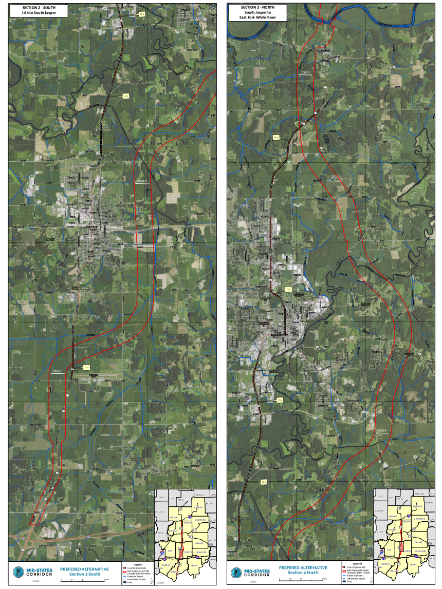
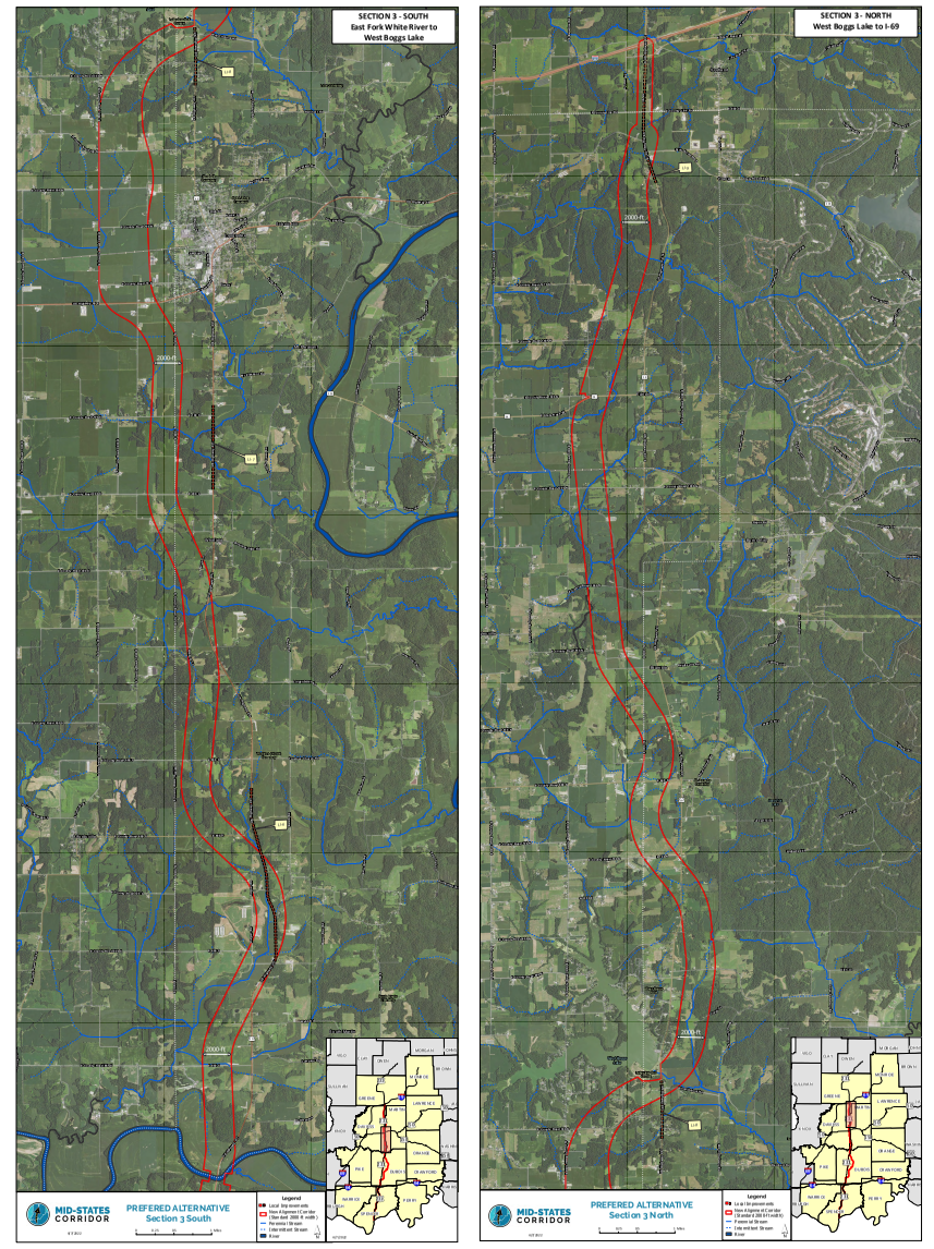
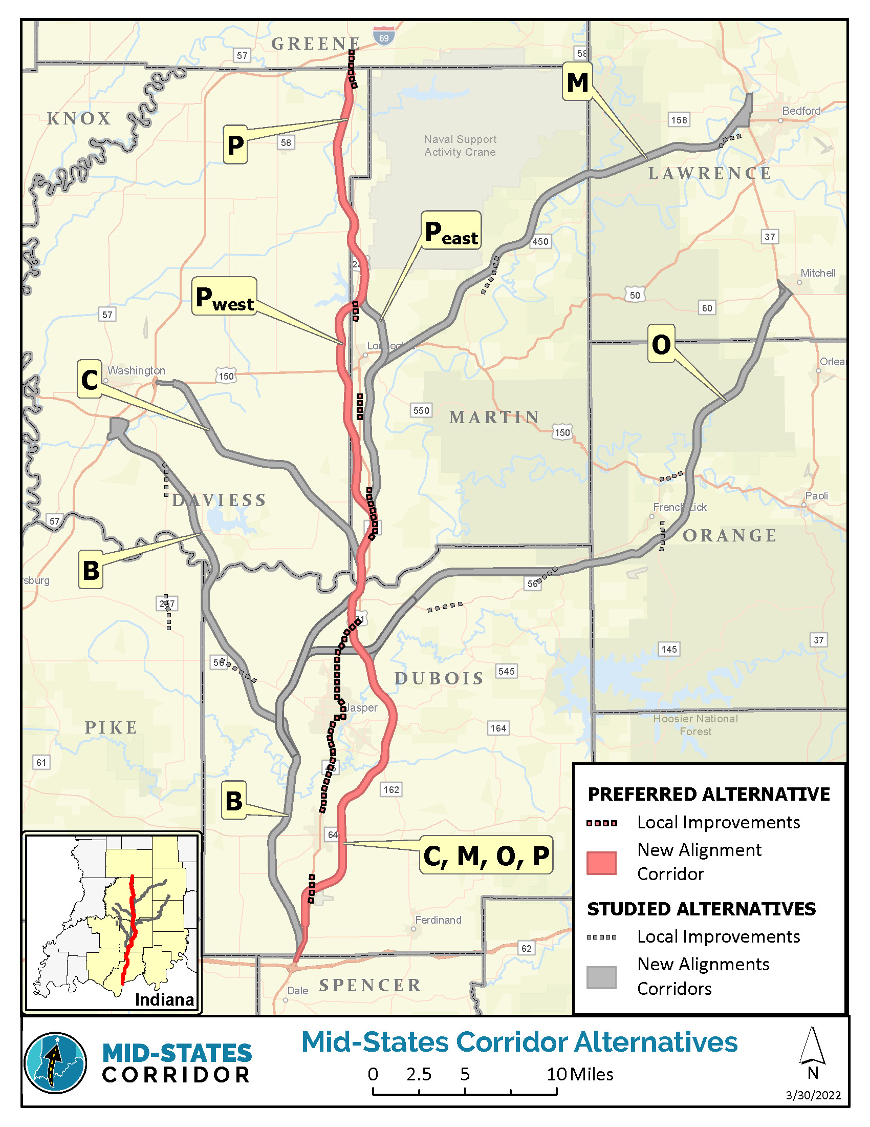
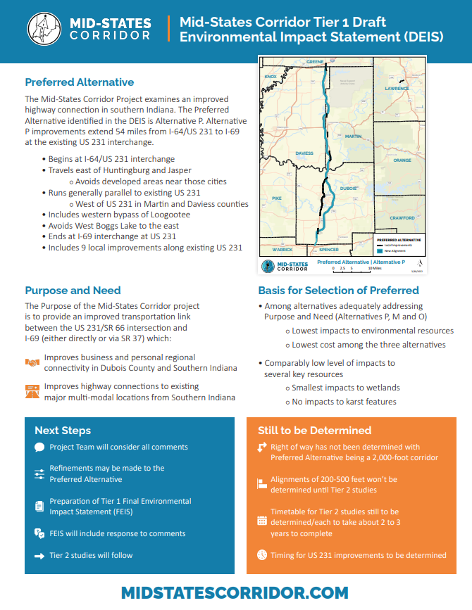
The Mid-States Corridor Project examines an improved highway connection in southern Indiana. The Preferred Alternative identified in the Draft Environmental Impact Statement (DEIS) is Alternative P. Alternative P improvements extend 54 miles from I-64/US 231 to I-69 at the existing US 231 interchange.
Preferred Alternative P
- Begins at I-64/US 231 interchange
- Travels east of Huntingburg and Jasper
- Avoids developed areas near those cities
- Parallels existing US 231 alignment to the west
- Includes western bypass of Loogootee
- Avoids West Boggs Lake to the east
- Crosses back west of existing US 231
- Continues north
- Ends at I-69 interchange at US 231
- Includes 9 local improvements along existing US 231
Watch this overview to learn more about the DEIS, the Preferred Alternative and next steps.
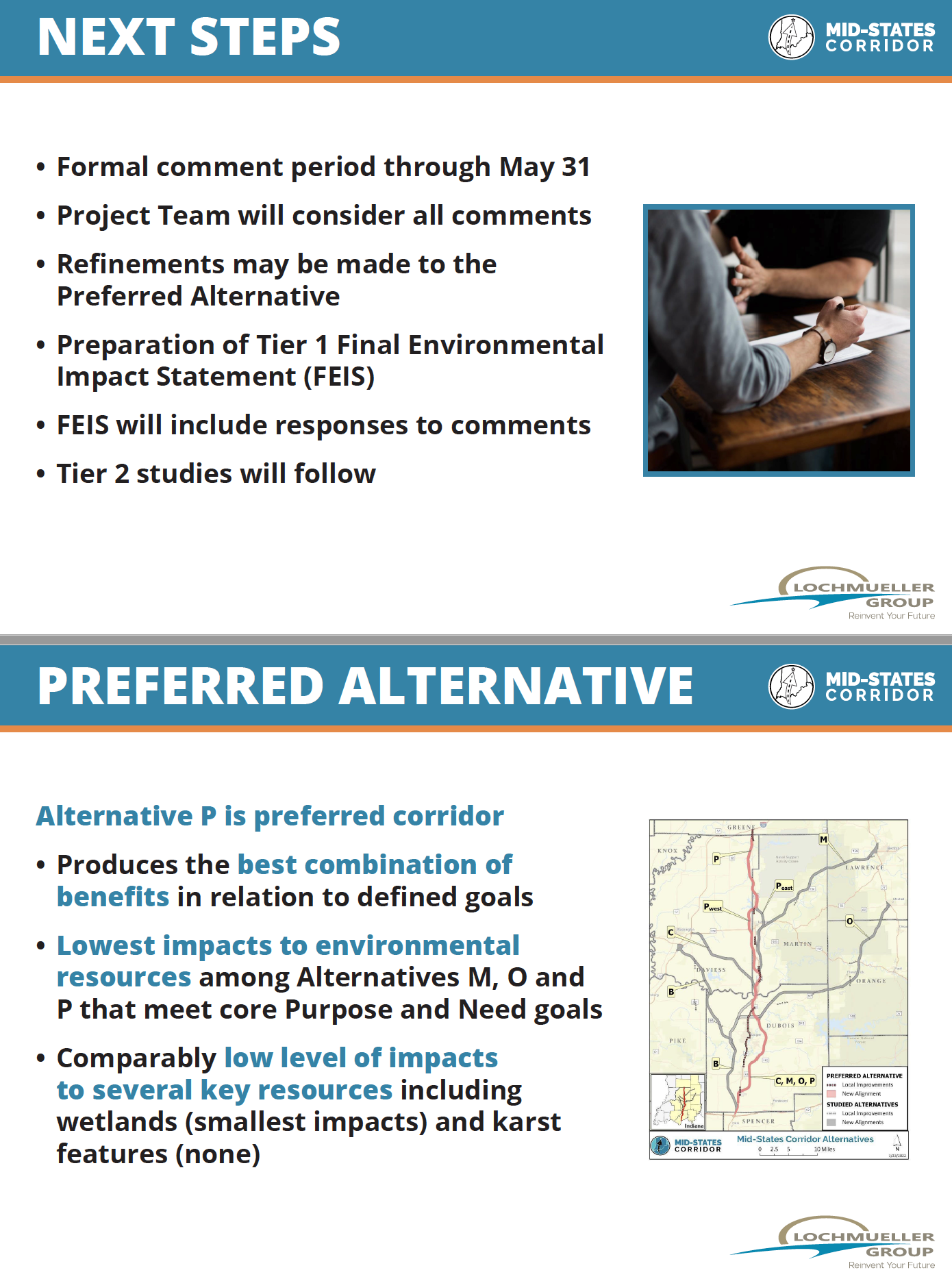
Among Alternatives adequately addressing Purpose and Need (Alternatives P, M and O), Alternative P has the lowest impacts to environmental resources, the lowest cost among the three alternatives and comparably low level of impacts to several key resources with the smallest impacts to wetlandsand no impacts to karst features.
The Purpose of the Mid-States Corridor project is to provide an improved transportation link between the US 231/SR 66 intersection and I-69 (either directly or via SR 37) which:
- Improves business and personal regional connectivity in Dubois County and Southern Indiana.
- Improves highway connections to existing major multi-modal locations from Southern Indiana.
The DEIS is a detailed document that summarizes the Mid-States Corridor project’s study process, analysis and findings. It assesses the benefits, impacts and costs of the alternatives. It includes the basis for the selection of the preferred alternative and key commitments associated with the project.
The DEIS remains available online and hard copies were available at several locations in the area.
- Bedford Public Library | 1323 K St.
- Bloomfield-Eastern Greene County Public Library | 125 S. Franklin St.
- Dubois Branch Library | 5506 E. Main St.
- Ferdinand Branch Library | 112 E. 16th St.
- Huntingburg Public Library | 419 N. Jackson St.
- Jasper-Dubois County Public Library | 100 3rd Ave.
- Lincoln Heritage Public Library | 105 Wallace St.
- Loogootee Public Library | 504 Park St.
- Melton Public Library | 8496 W. College St.
- Mitchell Community Public Library | 804 W. Main St.
- Monroe County Public Library | 303 E. Kirkwood Ave.
- Orleans Town and Township Public Library | 174 N. Maple St.
- Otwell Town Library | 2301 N. Spring St.
- Pike County Public Library | 1008 E. Maple St.
- Shoals Public Library | 404 High St.
- Spencer County Public Library | 210 Walnut St.
- Washington Carnegie Public Library | 300 W. Main St.
- Mid-States Corridor Project Office | 850 College Ave.
- INDOT Vincennes Office | 3650 Old US Hwy 41
- INDOT Indianapolis | 100 N Senate Ave.
Maps and Materials
Comment Period
The formal comment period For the Mid-States Corridor Tier 1 Draft Environmental Impact Statement has closed. There were several ways to provide comments during the formal comment period. All comments are considered equally, regardless of comment channel. Responses to comments are included in the Final Environmental Impact Statement (FEIS).
Draft Environmental Impact Statement (DEIS)
The Federal Register Notice for the DEIS was published April 15, 2022.
Environmental Impact Statement
Cover Page
Signature Page
EIS Summary
- Chapter 1 – Purpose and Need
- Chapter 2 – Alternatives
- Chapter 3 – Environmental Resources, Impacts and Mitigation
- 3.1 – Overview and Methodology
- 3.2 – Land Use Impacts (including Joint Development)
- 3.3 – Social Impacts
- 3.4 – Economic Impacts
- 3.5 – Relocation Impacts
- 3.6 – Indirect and Cumulative Impacts
- 3.7 – Traffic Impacts
- 3.8 – Title IV/Environmental Justice Impacts
- 3.9 – Air Quality Impacts
- 3.10 – Noise Impacts
- 3.11 – Wild and Scenic Rivers Impacts
- 3.12 – Construction Impacts
- 3.13 – Cultural Resources (Historic and Archaeological) Impacts
- 3.14 – Visual Impacts
- 3.15 – Properties of Environmental Concern
- 3.16 – Threatened and Endangered Species
- 3.17 – Floodplain Impacts
- 3.18 – Wetland Impacts
- 3.19 – Stream Impacts
- 3.20 – Groundwater Impacts
- 3.21 – Forest Impacts
- 3.22 – Mineral Resource Impacts
- 3.23 – Karst Impacts
- 3.24 – Agricultural Impacts
- 3.25 – Ecosystem Impacts
- 3.26 – Permits
- 3.27 – Managed Land Impacts
- 3.28 – Energy Impacts
- 3.29 – Short-Term Use Vs. Long-Term Productivity
- 3.30 – Irreversible and Irretrievable Commitment of Resources
- Chapter – 4 Section 4(f) Impacts
- Chapter – 5 Comparison of Alternatives
- Chapter – 6 Mitigation and Commitments
- Chapter – 7 Comments, Coordination and Public Involvement
- Chapter – 8 List of Preparers
- Chapter 9 – Distribution of DEIS
- Chapter 10 – References
- Chapter 11 – Glossary and Acronyms
- Chapter 12 – Index
Appendices
A – Transportation Performance Measures Analysis
B – Economic Development Performance Measures Analysis
C – Preliminary Alternatives Development
D – Screening of Alternatives Report
E – Working Alignment Typical Sections and Cost Estimating
F – Cumulative Impacts Baseline Trends
G – Cumulative Impacts Analysis Technical Report
H – Forest Impact Analysis
I – Threatened and Endangered Species Surveys
J – Floodplain Impact Analysis
K – Wetland Impact Analysis
L – Stream Impact Analysis
M – Groundwater Impact Analysis
N – Archaeology Analysis
O – Historic Properties Analysis
P – Section 106 Documentation
Q – Direct and Indirect Impacts to Farmland, Forests and Wetlands
R – Section 303(d) List – Impaired Waterbodies
S – Properties of Environmental Concern
T – Travel Forecasting Model Documentation
U – Land Use Plan Analysis
V – Local Improvements Analysis
W – Title VI/Environmental Justice Analysis
X – Geographic Information System Technical Documentation
Y – Karst Impact Analysis
Z – Agency Meetings and Correspondence
AA – Stakeholder Meetings and Correspondence
BB – Public Meetings and Correspondence
CC – Purpose and Need Appendix
DD – Social Impacts Appendix
EE – Economic Impacts Appendix (formerly Appendix U)
FF – Agricultural Impacts Appendix
GG – Managed Land Impacts
HH – Ecosystem Impacts Appendix
II – Media Outreach Appendix
JJ – Noise Analysis Appendix
KK – Section 4(f) Appendix
LL – Mineral Resources Appendix
MM – Wild and Scenic Rivers Appendix
Volume III – Environmental Atlas Part 1
Volume III – Environmental Atlas Part 2
Volume III – Environmental Atlas Part 3