


Final Environmental Impact Statement/Record of Decision (FEIS/ROD)
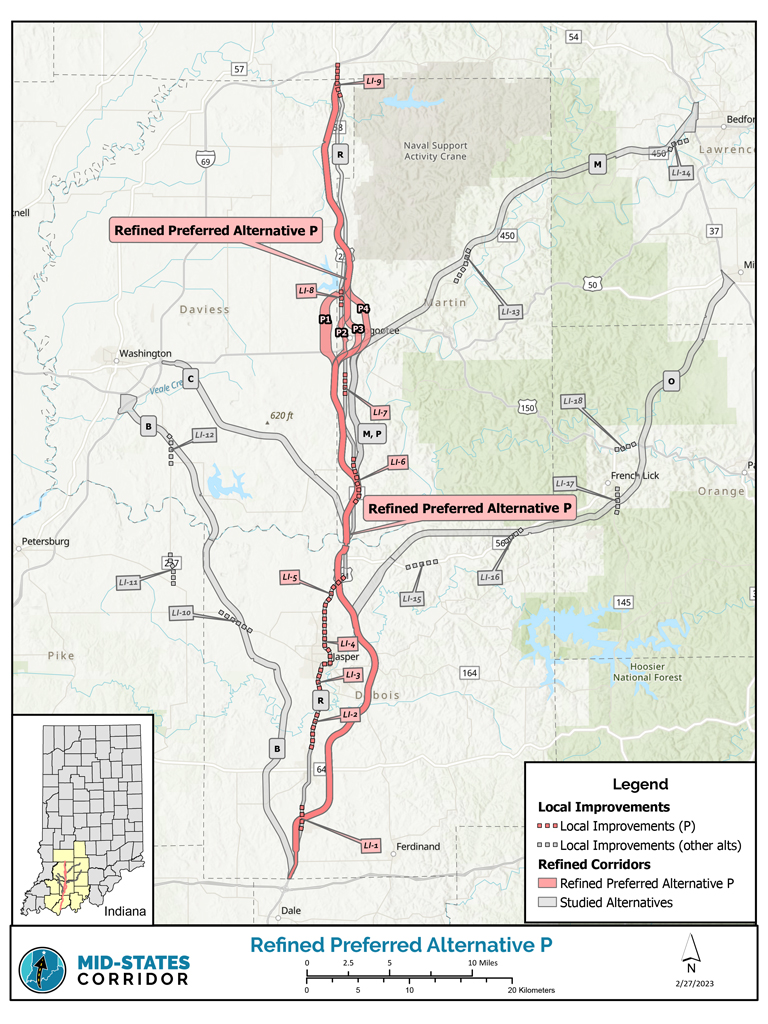
The Mid-States Corridor Project examines an improved highway connection in southern Indiana. The Preferred Alternative identified in the FEIS extends 54 miles from I-64/US 231 to I-69 at the existing US 231 interchange.
The FEIS is a detailed document that summarizes the Mid-States Corridor project’s study process, analysis and findings. It assesses the benefits, impacts and costs of the alternatives. It includes the basis for the selection of the preferred alternative and key commitments associated with the project.
The Final Environmental Impact Statement (FEIS)/Record of Decision (ROD) includes updates to the Tier 1 Draft Environmental Impact Statement (DEIS) based on agency and public input on the Draft Environmental Impact Statement. Responses to public and agency comments received on the Tier 1 DEIS are located in Volume IV of the FEIS/ROD.
The FEIS/ROD is available online and hard copies are available at several locations. Click here to view addresses.
- Bedford Public Library
- Bloomfield-Eastern Greene County Public Library
- Dubois Branch Library
- Ferdinand Branch Library
- Huntingburg Public Library
- Jasper-Dubois County Public Library
- Lincoln Heritage Public Library Dale
- Loogootee Public Library
- Melton Public Library
- Mitchell Community Public Library
- Monroe County Public Library
- Orleans Town and Township Public Library
- Pike County Public Library
- Shoals Public Library
- Spencer County Public Library
- Washington Carnegie Public Library
- Mid-States Corridor Project Office Jasper
- INDOT Vincennes District Office
- INDOT Indianapolis Central Office
- Lochmueller Group Evansville
The FEIS/ROD was published September 7, 2023 with an anticipated Federal Register Notice of Availability of September 15, 2023.
Environmental Impact Statement
Cover Page and Table of Contents
Signature Page
EIS Summary
Record of Decision
- Chapter 1 – Purpose and Need
- Chapter 2 – Alternatives
- Chapter 3 – Environmental Resources, Impacts and Mitigation
- 3.1 – Overview and Methodology
- 3.2 – Land Use Impacts (including Joint Development)
- 3.3 – Social Impacts
- 3.4 – Economic Impacts
- 3.5 – Relocation Impacts
- 3.6 – Indirect and Cumulative Impacts
- 3.7 – Traffic Impacts
- 3.8 – Title IV/Environmental Justice Impacts
- 3.9 – Air Quality Impacts
- 3.10 – Noise Impacts
- 3.11 – Wild and Scenic Rivers Impacts
- 3.12 – Construction Impacts
- 3.13 – Cultural Resources (Historic and Archaeological) Impacts
- 3.14 – Visual Impacts
- 3.15 – Properties of Environmental Concern
- 3.16 – Threatened and Endangered Species
- 3.17 – Floodplain Impacts
- 3.18 – Wetland Impacts
- 3.19 – Stream Impacts
- 3.20 – Groundwater Impacts
- 3.21 – Forest Impacts
- 3.22 – Mineral Resource Impacts
- 3.23 – Karst Impacts
- 3.24 – Agricultural Impacts
- 3.25 – Ecosystem Impacts
- 3.26 – Permits
- 3.27 – Managed Land Impacts
- 3.28 – Energy Impacts
- 3.29 – Short-Term Use Vs. Long-Term Productivity
- 3.30 – Irreversible and Irretrievable Commitment of Resources
- Chapter – 4 Section 4(f) Impacts
- Chapter – 5 Comparison of Alternatives
- Chapter – 6 Mitigation and Commitments
- Chapter – 7 Comments, Coordination and Public Involvement
- Chapter – 8 List of Preparers
- Chapter 9 – Distribution of EIS
- Chapter 10 – References
- Chapter 11 – Glossary and Acronyms
- Chapter 12 – Index
Appendices
A – Transportation Performance Measures Analysis
B – Economic Development Performance Measures Analysis
C – Preliminary Alternatives Development
D – Screening of Alternatives Report
E – Working Alignment Typical Sections and Cost Estimating
F – Cumulative Impacts Baseline Trends
G – Cumulative Impacts Analysis Technical Report
H – Forest Impact Analysis
I – Threatened and Endangered Species Surveys
J – Floodplain Impact Analysis
K – Wetland Impact Analysis
L – Stream Impact Analysis
M – Groundwater Impact Analysis
N – Archaeology Analysis
O – Historic Properties Analysis
P – Section 106 Documentation
Q – Direct and Indirect Impacts to Farmland, Forests and Wetlands
R – Section 303(d) List – Impaired Waterbodies
S – Properties of Environmental Concern
T – Travel Forecasting Model Documentation
U – Land Use Plan Analysis
V – Local Improvements Analysis
W – Title VI/Environmental Justice Analysis
X – Geographic Information System Technical Documentation
Y – Karst Impact Analysis
Z – Agency Meetings and Correspondence
AA – Stakeholder Meetings and Correspondence
BB – Public Meetings and Correspondence
CC – Purpose and Need Appendix
DD – Social Impacts Appendix
EE – Economic Impacts Appendix
FF – Agricultural Impacts Appendix
GG – Managed Land Impacts
HH – Ecosystem Impacts Appendix
II – Media Outreach Appendix
JJ – Noise Analysis Appendix
KK – Section 4(f) Appendix
LL – Mineral Resources Appendix
MM – Wild and Scenic Rivers Appendix
NN – Post-DEIS Loogootee Outreach
OO – Amish Outreach
PP – Tier 1 Biological Assessment
QQ – Biological Opinion
RR – Greenhouse Gas Analysis
SS – Air Quality Conformity Determination
Volume III – Environmental Atlas Alternative B
Volume III – Environmental Atlas Alternative C
Volume III – Environmental Atlas Alternative M
Volume III – Environmental Atlas Alternative O
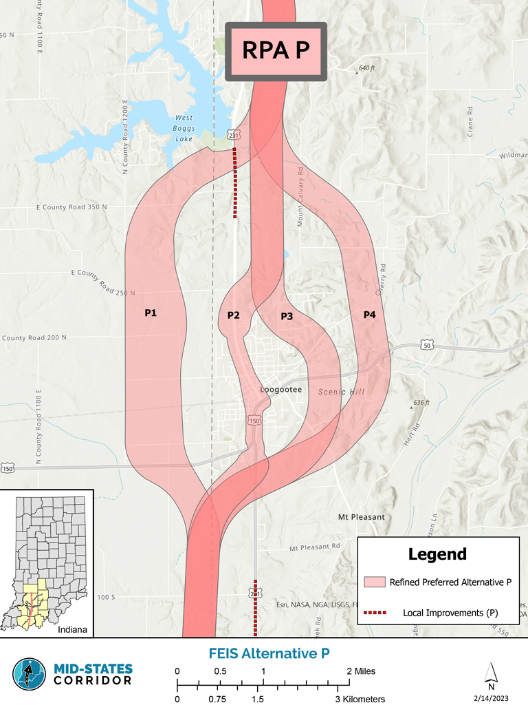
Volume III – Environmental Atlas Alternative P
Volume III – Environmental Atlas Alternative R
Volume III – Environmental Atlas RPA P
Volume IV-DEIS Comments and Responses
Maps and Information
Corridor Map

Download High Resolution Map
Mid-States Combined FEIS/ROD Published
September 7, 2023
Federal Register Notice of Availability scheduled for next week
The Federal Highway Administration (FHWA) and the Indiana Department of Transportation (INDOT) have issued a Tier 1 Combined Final Environmental Impact Statement/Record of Decision (FEIS/ROD) for the Mid-States Corridor Study. The document includes changes to the Draft Environmental Impact Statement (DEIS) based on agency and public input. The FEIS/ROD was published today with an anticipated Federal Register Notice of Availability of September 15, 2023.
The Tier 1 Studyof an improved highway connection in southern Indiana is a product of the successful partnership of the Mid-States Corridor Regional Development Authority and INDOT. The Preferred Alternative extends 54 miles from I-64/US 231 to I-69 at the existing US 231 interchange. The FEIS/ROD is available for viewing online at https://midstatescorridor.com/feis/ and at the following library locations. Location addresses are provided at the link.
| Bedford Public Library | 1323 K St. BedfordIN 47421 |
| Bloomfield-Eastern Greene County Public Library | 125 S. Franklin St. BloomfieldIN 47424 |
| Dubois Branch Library | 5506 E. Main St. Dubois IN47527 |
| Ferdinand Branch Library | 112 E. 16th St. FerdinandIN 47532 |
| Huntingburg Public Library 419 N. Jackson St. Huntingburg | 419 N. Jackson St. HuntingburgIN 47542 |
| Jasper-Dubois County Public Library | 100 3rd Ave. JasperIN 47546 |
| Lincoln Heritage Public Library | 105 Wallace St. DaleIN 47523 |
| Loogootee Public Library | 504 Park St. LoogooteeIN 47553 |
| Melton Public Library | 8496 W. College St. MeltonIN 47432 |
| Mitchell Community Public Library | 804 W. Main St. MitchellIN 47446 |
| Monroe County Public Library | 303 E. Kirkwood Ave. BloomingtonIN 47408 |
| Orleans Town and Township Public Library | 174 N. Maple St. OrleansIN 47452 |
| Pike County Public Library | 1008 E. Maple St. PetersburgIN 45767 |
| Shoals Public Library | 404 High St. ShoalsIN 47581 |
| Spencer County Public Library | 210 Walnut St. RockportIN 47635 |
| Washington Carnegie Public Library | 300 W. Main St. WashingtonIN 47501 |
| Mid-States Corridor Project Office | 850 College Ave. JasperIN 47546 |
| INDOT Vincennes District Office | 3650 Old US Hwy 41 VincennesIN 47591 |
| INDOT Indianapolis Central Office | 100 N Senate Ave. IndianapolisIN 46204 |
| Lochmueller Group | 6200 Vogel Rd. EvansvilleIN 47715 |
The Mid-States Corridor Study is a tiered environmental document consistent with the guidance established by the Council of Environmental Quality (CEQ) under the National Environmental Policy Act (NEPA) and conforming to processes developed by FHWA and INDOT. Tiering separates the broader issues, such as selection of the general location and mode choice in Tier 1, from the more detailed site-specific impacts in Tier 2. With the selection of Refined Preferred Alternative P, INDOT is following department processes for proceeding with the Tier 2 studies. Procedures include reviewing section priority before determining a timeline for the next phase of study.
The FEIS/ROD includes updates to the Tier 1 DEIS. Responses to public and agency comments received on the Tier 1 DEIS are in Volume IV of the FEIS/ROD.
Under Title 23 U.S.C. Section 139, the FHWA has issued a single document that consists of a FEIS and ROD. Therefore, the 30-day wait/review period under NEPA does not apply to this action.
Media inquiries should be directed to Nicole Minton at nicole.minton@lochgroup.com